 |
|
|
|||||||||||||||||||||||
|
Interferometry
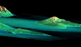
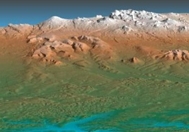
To understand how the latest, most accurate map of the Earth was made, close one eye. Now open it and close the other. The scene before you shifts, ever so slightly, but even that slight difference provides essential information. By having two eyes next to each other, even if they're only a few centimeters apart, humans (and other animals) acquire the magic gift of depth perception. Try it out - close one eye and reach for a floppy disk or your pen or something. Suddenly you can't tell precisely where anything is. Your desk seems right next to the wall, even though you remember dropping a book behind it a couple of days ago. With only one eye, the world becomes two-dimensional, having height and width but not depth. Being aware of three-dimensional space is incredibly important - it allows you to do things like go upstairs and pick up your fork. This need for three-dimensional information is why the Space Shuttle Endeavour has just completed a mission that will result in the most accurate maps of the earth's surface ever produced. The Endeavour's mapping mission was unique in several ways. First, the mapped area covered nearly 80 percent of the world's land, from 60 degrees north latitude (Hudson's Bay) to 56 degrees south latitude (the Cape of Good Hope). This area also happens to contain the most easily habitable areas and thus 95 percent of the earth's people. More importantly, all the mapping data were collected in the same way and with the same instruments, so the information is uniform across the entire globe. The specific technique used was not unique to the mission. Radar interferometry is basically just an electronic form of depth perception. By using radar waves instead of light, however, it can peer through clouds, forests, dust storms, or other phenomena that can block the view of earth from space. It is also extraordinarily accurate. The Shuttle mission used "single-pass" radar interferometry, which meant that it recorded two sets of data simultaneously.
In its payload bay the Space Shuttle carried all the equipment necessary: a radar generator that beamed radar waves at the earth's surface, and a mast to hold one of two antennas that received the data. One antenna in the payload bay recorded the first set of reflected waves while another receiver at the end of a 60-meter-long rigid mast collected a second set of data. By closely comparing the two sets of data cartographers can generate topographical information to an accuracy of 30 meters, a far more detailed and more consistent level than any earlier global maps. As part of the attempt to ensure accuracy, the Endeavour's altitude had to be consistently measured with a high degree of accuracy, using radar and the Global Positioning System. Sweeping the globe in 230-kilometer-wide swaths, Endeavour managed to map millions of kilometers and to record 222 hours of digital data - 12 terabytes' worth. The data were stored on high-capacity tapes that will be analyzed at the Jet Propulsion Laboratory in Pasadena. Analyzing the data and making actual maps will take several years. The National Imagery and Mapping Agency, NASA's partner in the mapping mission, will use the data to develop detailed maps for strategic purposes. But the new maps will also have civilian uses in fields such as road construction, environmental preservation, and hydrology. An irony of sorts is that satellites had already collected such accurate data of a planet - but the planet wasn't this one. Before the Endeavour's mission, scientists had more consistently accurate maps of Mars and Venus than of Earth. Copyright © 1999, 2000 media.org. |
||||||||||||||||||||||||
|