 |
|
|
|||||||||||||||||||||||
|
Meridian
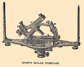
Spheres do not have any natural direction; for example, one would never speak of the "top" or "bottom" of a baseball. What makes the Earth different from a baseball is spin - the planet rotates around its axis, creating not only day and night but also the north and south poles, the two places on the globe that do not move. By using the poles as reference points, the three-dimensional globe can be reduced to two dimensions measurable on a grid - latitude and longitude. Finding the latitude, or distance from the equator, is fairly easy: Take a stick and poke it in the ground. Draw a line in the ground at the end of its shadow. The time of day when the shadow is shortest is noon, while the day of the year when the shadow is longest is December 21, in the northern hemisphere, or June 21 south of the equator. The shadow's angle can be used to calculate the latitude; instruments such as the sextant measure the angle of a celestial object on a specific day, though they use stars other than the sun. Latitude is measured in height north or south of the equator, and lines of equal latitude are called "parallels" because they are parallel to the equator. Finding the longitude is altogether more difficult - longitude lines converge towards the poles and their distance from each other varies with latitude. In addition, there's no logical starting point, so ancient geographers used to find their own. Longitude lines are called "meridians," from the Latin "meridiem," or "middle of the day," because on any meridian the sun is overhead at noon, and a meridian used as a starting point is a "prime" or "first" meridian. In the second century B.C. Hipparchus of Rhodes proposed that all distances be measured from a meridian running through the island of Rhodes, just off the southern coast of Turkey. (Oddly enough, many astronomers and heads of state felt that their own city of residence deserved to be the starting point for measuring the entire world.) Three hundred years later, between 127 and 141 AD, the astronomer Ptolemy proposed a prime meridian through the Fortunate Islands, now known as the Canaries. This location allowed all of Europe to be measured from that one direction and made good sense, though Ptolemy's estimate of the earth's size proved to be famously wrong. In 1601 the globe maker Hondius put a prime meridian through the Azores, because supposedly at that location a compass needle pointed true north. This seemed like a reasonable idea, but had the serious disadvantage of a flawed basic premise: The magnetic poles wander around, so although the Azores would be as good a place for a meridian as any, accurate compass direction is irrelevant. Another cartographer moved the prime meridian back to the Canaries, specifically to Tenerife, which has a prominent mountain that makes a good observation point. Soon things began to get out of hand as every nation began proposing its own meridian system. French cartographers used a meridian that ran through Paris, while a Scottish astronomer proposed a prime meridian at the Great Pyramid of Giza, which was desirable not only because it was a high, fixed point but because it was close to Jerusalem, the spiritual prime meridian of the faithful. Another astronomer proposed a meridian through the Pacific, precisely because it was uninhabited. In 1816 the United States established a prime meridian that ran through the White House and up 16th Street, giving Meridian Hill its name and freeing the fledgling country from depending on Greenwich-based British charts. But by 1816 England already had the advantage in terms of whose meridian was most useful. In 1675 John Flamsteed established a royal observatory at Greenwich, England, where he built a transit circle. This is a specific type of telescope that measures the time and specific elevation, of a star as it passes overhead. The observations of Flamsteed and his successors made British navigational tables exceptionally accurate and reliable, and thus popular with sailors and cartographers. By the mid-19th century most charts used as their zero point the meridian at Greenwich. Still, some sort of international agreement seemed necessary. In 1884 the question of where to locate the Prime Meridian was settled at a conference in Washington, D.C. Delegates from 25 nations met to decide where the international standard prime meridian would be located. The vote was laughably lopsided: 22 nations favored Greenwich, San Domingo opposed the location, and France and Brazil abstained, unwilling to vote for a British meridian but resigned to its widespread use. As a result, the entire world now sets its clocks by Greenwich Mean Time and measures its longitude in distance from the Greenwich Prime Meridian. Measurements are expressed as being either east or west of Greenwich; the International Date Line is exactly half-way, or 180 degrees, around the world. Copyright © 1999, 2000 media.org. |
||||||||||||||||||||||||
|