 |
 |
Martin Dodge is a
Researcher in the Centre for Advanced Spatial Analysis (CASA), University College London and is the creator of the Atlas of Cyberspaces.
» Previous Issues
|
|
|
Further Reading:
» (1) For more information on the history of the Net, the following resources are recommended.
Online:
Leiner, B.M., Cerf V.G., et al., (1998), A Brief History of the Internet
Hobbes' Internet Timeline
Books:
Hafner, K. & Lyons, M., (1996),
Where Wizards Stay up Late: The Origins of the Internet, (Simon & Schuster: New York).
Salus, P.H., (1995),
Casting the Net: From ARPANET to Internet and Beyond, (Addison-Wesley Publishing Company: Reading, MA).
» (2) BBN still provides networking services, but is no longer an independent company having been taken over by GTE in 1997.
» (3) For examples of these maps see:
Atlas of Cyberspaces - Historical Maps,
ARPANET Maps page by Larry Press
» (4) www.rfc-editor.org
|
|
|
|
|

Buy the Book Today!
|
|
|
|
|
|
|
|
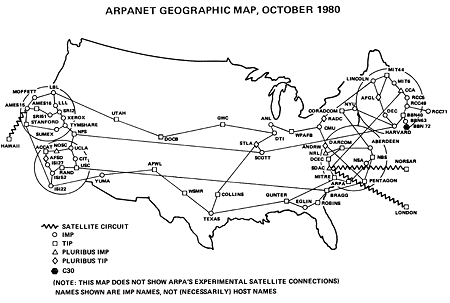
ARPANET (October, 1980)
Welcome to the Cybermap of the Month column where I will be examining all the best examples of maps and visual spatial representations of Cyberspace over the coming months. As we shall see all manner of graphical styles are being employed by researchers and enthusiasts to chart the electronic terrains of Cyberspace. Some of the examples may not necessarily be recognised as maps in the conventional sense, and in fact they are pushing the boundaries of cartography. To kick off this column I look back into the dim and distant past of Cyberspace, (well nearly 20 years ago) to a historical map that uses many conventions of geographic maps to show the network structure of the ARPANET. [1]
ARPANET pioneered wide-area computer networking and very much laid the foundations of the Internet we know today, developing both the technical and social infrastructure of internetworking. It was funded by the US military, through the ARPA agency to link together key labs undertaking advanced defence-related research. Construction of the network infrastructure began in 1969 by the Bolt Beranek and Newman (BBN) [2]
company, with the first node of the network installed at the University of California Los Angeles in September of 1969. The network was built as a distributed, decentralised system with each node of equal importance and used packet switching protocols.
ARPANET grew rapidly from that first node in 1969 and its expansion was charted in a fascinating series of maps used by the BBN engineers who built and managed the network. [3] Some of the first maps were merely sketches of the topology of the links between nodes, completely ignoring real-world geography. As the network grew larger, connecting more and more distant places, the maps plotted the locations of the nodes on a base map of the outline of the USA. I have chosen one of the geographic maps from October 1980, around the middle of ARPANET's life. This is a typical example and shows around seventy nodes in the network and the connections between them. The nodes were the equivalent of today's routers and connected a couple of hundred host computers and several thousand active users.
The most striking feature of this map is the great concentration of sites in California and the Northeast of the USA, with a scattering of nodes in the interior; clearly revealing the density of military funded research in these regions. The cartographic style is simple and functional, using an arc-node representation. (This form of representation is commonly used to map all manner of networks, not just computer ones.) Different types of nodes are shown by square, diamond, and triangle symbols drawn on the map in the approximate geographic location of the site, along with a name label. The network connections between sites are represented by black lines, joining the dots together. Magnifying circles are employed to show the densest concentration of nodes in northern and southern California, and the Boston and Washington regions at a greatly exaggerated geographic scale. The route of the connections are obviously an abstraction from geographic reality as they are drawn as dead straight lines. The links were in fact formed by telephone wires leased from AT&T which did not run in straight lines! However, this reality was superfluous to the purpose of the maps, it was sufficient to indicate the logical topology and not where the wires actually ran in the ground.
The map also shows that ARPANET had a few nodes outside of the continental USA. There was a node in Hawaii and two in Europe (in Norway and London, which had been added in 1973). The overseas links were carried by satellite circuits which are represented by the wavy lines on the map. The node in London was located at
University College London (where I currently work).
These maps of ARPANET may be simple black and white line drawings, but they are now of historical importance because they were created by the people who built the network to chart its size and approximate geographic structure and significantly because they record what no longer exists. ARPANET has long since been decommissioned, having been officially "turned-off" in 1989. [4] It was superseded and replaced by faster, more sophisticated networks and these maps provide one of the few tangible traces of its existence.
Copyright © 1999, 2000 media.org.
ISSN: 1530-3314
|
|