 |
|
|
|||||||||||||||||||||||||||||||||||||||||||||||||||||||||||||||||||||||||||||||||||||
|
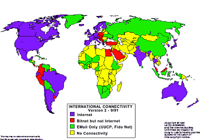
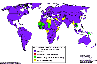
Mapping the Global Spread of the Net During the 1990s the Internet spread, virus-like, across the globe, and by 1997 most of the nations of the world were connected. This virulent diffusion of the Internet was tracked by Larry Landweber in a series of maps. He produced twelve maps over a period of six years, providing us with a useful and fascinating visual census of the spread of international network connectivity [1]. Landweber, who is Professor of Computer Science at the University of Wisconsin-Madison, has long been active in the development of computer networking and fostering the global spread of the Internet by helping in establishing gateway connections to the USA. He was also the prime mover in the development of the TheoryNet and CSNET networks in the late 1970s and 1980s - significant milestones on the development of the Net. The first map Landweber released from September 1991 is shown below and the second map is his last in the series of international connectivity maps created in the summer of 1997. Comparing the two maps, it is clear that a great deal of the world was connected to the Internet in those six years.
Landweber's global maps show all the countries of the world their level of international network connectivity at particular points in time. There are four distinct classes of international connectivity, shown on the maps by the different coloured shadings of the countries. The bottom class is no connectivity, which is represented by shading the country yellow. Two intermediate levels, of connectivity to networks for e-mail only and to BITNET, are shown by green and red. (See the previous Map of the Month article on John December's Conceptual Net Map for some background on these networks). The top category of permanent Internet connectivity, offering a full range of interactive services, is represented in blue. This classification and colour-coding was applied consistently to the countries throughout Landweber's series of maps allowing one to track changes over time. Data on the changing state of network connectivity in different countries was gathered by Landweber from a network of human contacts across the world. So what do these maps reveal about global Internet diffusion through the 1990s? The first map, from 1991, shows a large number of countries coloured blue, and therefore with full Internet links, particularly in the Americas and in Northern Europe. But an equally large measure of the world's nations were shaded yellow, indicating that they had no international connectivity. In fact this category included well over half the nations of the world, though these were clearly concentrated in the less developed regions of Africa and central Asia. By 1997, the majority of the nations of the world were shaded blue. The Internet, as measured by Landweber's survey, was so widespread that the exceptions really stand out. (It was at this point that tracking diffusion at this scale became redundant and, hence, this is the last map in the series.) The yellow shaded exceptions were nations suffering from extreme poverty, war and civil conflicts (such as Afghanistan and Somalia) or from geopolitical isolation (e.g. Libya, North Korea, Burma, Iran and Iraq). Landweber was not alone in his concern for the global diffusion of the Internet (see table at bottom). Other notable work in tracking and mapping the geographic diffusion of the Internet includes that of Olivier Crepin-Leblond, John Quarterman / MIDS, and Mike Jensen. Crepin-Leblond consistently maintained the International E-mail Accessibility[2] survey from 1993 to 1997 and produced a number of maps of the data using a similar cartographic approach to Landweber. John Quarterman and his company MIDS[3] have long been tracking and mapping the growth and diffusion of computer networks, producing a wide range of maps. (See my Map of the Month article on the MIDS Internet World Map for more detail.) Mike Jensen, a networking consultant in South Africa, produces important surveys and maps of Internet connectivity for the African continent[4].
Landweber's maps represent data by shading countries according to a classification scheme. This is a very common cartographic design approach known as choropleth mapping[5] which is widely used to map statistical data. It is easy to assume that these maps provide a clear and straightforward geographic presentation of the data. However, this is not always the case and one must interpret them carefully to avoid drawing naive and unsound conclusions about the patterns in the data. In the case of the International Connectivity maps, an uncritical reading of them could easily provide a distorted view of the global spread of the Internet. Firstly, it is important to realise what exactly Landweber was measuring: international connectivity at the national level. The maps ascribe a single value to a whole country, suggesting that everywhere and everyone within this area has equivalent levels of Internet connectivity. Clearly this is not the case, even in the most networked nations, as recent concern over 'digital divides' has highlighted. The second way the Landweber maps can deceive the unwary reader is that very different countries appear to be same. Due to the limited range of categories, nations appear visually similar on the map when in reality their level of Internet connectivity can be very different. Countries are coloured blue if they have permanent international links to the Internet, but these links may be a small number of satellite connections (expensive, low bandwidth) in a few major cities, or numerous high-capacity fibre-optic cables linking all parts of the country to the Internet. To the unwary eye, both cases can appear the same on the map. For example: in the September 1991 map, the three nations of North America are all shaded blue, indicating they are in the same group because they all have Internet connectivity, yet it is clear that Mexico was not in the same league as the USA and Canada in terms of how widespread and affordable the Internet was. In the final map produced by Landweber in June 1997, a large proportion of the nations of the world have Internet connectivity, but one must be aware of the wide variations among nations in the degree of connectivity. Maps, by their very nature, always distort reality to some degree. One needs to interpret them in a critical fashion and I strongly recommend the book How to Lie with Maps[6] by Mark Monmonier - a professor of geography at Syracuse University - for an enjoyable introduction to the multitude of ways of deliberately and unintentionally using cartography to deceive. Landweber's maps showed, on a national scale, how the Net spread across the world in the 1990s. I believe the key challenge now is to try to understand, and map, how the Net is diffusing at the smaller scale, within countries, cities and neighbourhoods. This is quite a challenge for data collection, analysis and cartographic presentation.
There has been much scholarly work to try and understand the prerequisites and processes behind the global diffusion patterns indicated by Landweber's maps. At one level, clear relationships between measures of wealth and Net connectivity have been found, but the underlying processes are likely to be more complex. For example, it is important to factor in variations in social and cultural practices in the adoption and use of technology, as well as the differing political and regulatory structures of countries. If you are interested in exploring this field of research further, I'd recommend the following papers:
Copyright © 1999, 2000 media.org. ISSN: 1530-3314 |
||||||||||||||||||||||||||||||||||||||||||||||||||||||||||||||||||||||||||||||||||||||


|