 |
|
|
||||||||||||||||||||||||||||||||||||||||
|
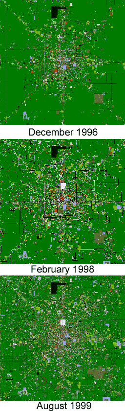
Mapping A Virtual City What would a virtual city in cyberspace look like? Well, a sequence of 'satellite' maps of AlphaWorld provide us with a pretty good idea These fascinating maps show the growth of buildings, streets, parks and gardens designed and constructed by the citizens of the virtual world of AlphaWorld over the past five years. The virtual cartographer responsible is Roland Vilett, the lead programmer on the virtual world system at Activeworlds.com, which encompasses AlphaWorld and several hundred other worlds on the Internet (see sidebar for further details). Note that these images have been shrunk significantly to make them fast-loading. The link takes you to the full-sized images which provide glorious detail of the urban geography of the city. In a recent email interview for Mappa.Mundi, Roland Vilett talked about his maps, revealing that the idea of mapping the virtual geography of AlphaWorld had been floating around the programming team for a while and then "one idle Sunday afternoon" at the end of 1996 he realised he had all the pieces needed to create a program to generate the maps.
AlphaWorld comprises a massive virtual space, exactly 429,038 square kilometres, an area four percent larger than California. It opened to the general public on the Internet in June 1995, beginning sustained colonisation with many thousands of people leading a virtual land-rush to claim the terra nullius of AlphaWorld. The virtual space came into existence as a flat, featureless plain stretching for hundreds of virtual kilometres in every direction, coloured a lush shade of green to denote that it was virgin territory waiting to be claimed by bold homesteaders. There were no 'natural' features, no mountains or rivers, just a perfect green plain sheltering under a unceasing bright blue sky. Everything that now exists in AlphaWorld - 48.9 million objects as of February 2000 - has been placed there by the homesteaders, using simple block-building tools. Of course, the virtual geography of AlphaWorld, with all its buildings and trees, is a illusion of 3d computer graphics conjured from a big database running on some anonymous Internet server machine. Nevertheless it is a convincing illusion that can be shared over the Net. The 'downtown' of AlphaWorld is known as Ground Zero (GZ) to the locals and is the focal point for their world because this is the place at which one arrives by default. Consequently, the land around GZ is always the most densely populated and built-up. Vilett's map show the city that has grown out from GZ. In fact, his maps cover a mere 0.3 percent of the total expanse of the world - just 400 square kilometres around GZ. However, this is where most of the building has occurred.
The maps revealed several surprising features of the AlphaWorld's urban geography. "The first and most obvious impression was just how much the map looks like the map of a city in the real world," according to Vilett. It has the seemingly organic complexity and disorderliness of real cities, which grow over time through many thousands of individual actions. This likeness is clearly apparent if you compare Vilett's maps of AlphaWorld's city to remotely sensed images at a similar scale of real world cities [1]. The densely built city centre around GZ sprawls out in all directions for many kilometres. Ribbons of urban growth project even further out along the principal compass axes to form a distinctive star shape. The geographical structure of urban development is believed to result in part from the use of teleportation as the principal means of travelling over distance in the world. Teleportation uses a cartesian co-ordinate system to specify locations in AlphaWorld and the cardinal directions have special meaning as Vilett notes - "I assume these coordinates are desirable in that they are easier to remember, causing a greater portion of people to build their homes along the diagonals". So human nature means people tend to choose regular and memorable co-ordinates, such as 50N, 50W the location for their homestead and once a pioneer has started building in that direction other citizens will build alongside, either by invitation or just to be close to other people. The extent of urban growth, spreading out from GZ, in the three-year time period is clearly apparent when the maps are compared. The star-shaped urban structure is most evident in the first map, from the end of 1996, and then it gradually dissolves as fill-in development in the desirable land around GZ has continued apace. The remaining unclaimed land, shown as dark green on the map, has shrunk greatly through inexorable urban sprawl. If you studying the maps further many interesting features and details can be discerned. For example, a complex lattice of roads, represented by the fine black lines, criss-cross the plain. Areas of light blue, denoting rivers, ponds and lakes also stand out. Another notable phenomena revealed, and greatly encouraged, by the maps is 'sky writinge . People deliberately draw large words on the ground that are visible and legible from high in the air. Obvious examples include the words 'PLATTER' and 'RAGU', and "…the number of incidents of 'sky-writing' increased dramatically after we made the first map," says Vilett. Perhaps the most striking single feature on the three maps is the large black area at the top-middle of the map which is "an extremely large 'land claiming' project that dates back to the earliest days of AlphaWorld", according to Vilett. One must also be aware there is much not revealed in the maps. For example, because of the scale of the map, each pixel in the image has to represent a 10 x 10 metre plot on the ground so many small features can not be shown. Also, the AlphaWorld is a three dimensional place with buildings of different heights and some features underground. This is obviously not apparent from the two-dimensional maps [2]. The map also does not reveal how active and well-used are the different parts of the city. Unfortunately, there is a problem one could term, 'virtual ghost towns,' where too much of the land and buildings in AlphaWorld have been abandoned by its original homesteaders. Because of the system's rules of land ownership, no else can then occupy this territory once it has been abandoned. And, because this is cyberspace, the buildings forever remain pristine clean, never decaying. The gardens never become overgrown and no one ever visits. Lastly, Vilett reveals that, "…the one small home I built years ago is way out in the 'boondocks' of AlphaWorld so it is not visible on the map."
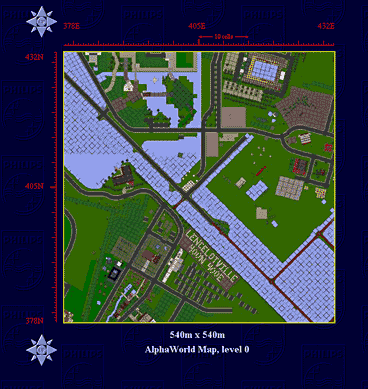
Vilett's cartography provides us with city-wide 'satellite' maps, but if we want to see more of the local detail and texture - what the buildings, trees and structures are really like in one's own backyard - then we have to go down scale. We need the equivalent of aerial photographs[3] of the virtual geography of AlphaWorld. Luckily, another ambitious AlphaWorld mapping project provides a tremendous interactive map of the whole of the 400-thousand square kilometres expanse of the world right down to the 'backyard' scale of aerial photos. This sophisticated mapping system was developed by Greg Roelofs and Pieter van der Meulen at the Philips Silicon Valley Center [4], providing maps of AlphaWorld at twelve different scales. An example below shows one of their most detailed levels of 'aerial photo' style mapping, where each pixel in the image represents one metre on the ground. One can see the fine detail of roads, the pond, trees and the buildings, along with some more 'sky writing'. While using the compass icon you can easily pan the map view in any direction or move upscale to see a larger area. Their mapping system is also kept up-to-date, with a new version usually generated every three months. The highest resolution map can actually be used as a powerful teleportation tool to beam yourself into the world.
Vilett's background is in computer science and he has been involved with programming the Active Worlds system from the beginning in 1995. His maps of the virtual city have provided us with a most powerful view of this part of Cyberspace, even though, as he says, "I have no formal background in cartography but maps have been a fascination of mine since early childhood, and have been an ongoing hobby for me ever since." The maps have revealed a city cyberspace - and a city that looks remarkably like the bricks-and-mortar ones in the real world. Copyright © 1999, 2000 media.org. ISSN: 1530-3314 |
|||||||||||||||||||||||||||||||||||||||||


|