 |
|
||||||||||||||
|
Mapping MUDs
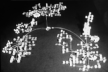
Multi-user dimensions, or MUDs for short, are a unique and strange part of the Net [1]. MUDs are virtual spaces created solely by written words; their space unfolds on the computer screen as scrolling text. MUDs are also social spaces shared by many players who are able to interact with each other and with the environment around them. The experience of MUDding (playing on / in a MUD) is often described as like being inside a literary novel, but not just a reader. The MUD is a living novel, being written in real-time by its players. MUDs are particularly interesting to us because they have a complex geography, compared to other real-time Net spaces like chat rooms or IRC channels. MUD geography comprises many interlinked spaces, known as rooms, which form maze-like topologies that players can explore and use. A room is conjured-up in the mind of players purely by its textual description, such as Narthat Street (A typical room description taken from DragonMud) Obviously, not all rooms are actual interior rooms of buildings, many are outside scenes. In the Narthat Street example the room is connected to another six rooms by its exits. To get some sense of the topological structures of room connections of a MUD one can map it [2]. One of the most notable efforts to map the topology of MUDs was undertaken by architect, Peters Anders and his students at New Jersey Institute of Technology [3]. Anders, in an email interview, said his motivation to map MUDs was because they are designed by the players rather than professional architects, and they offered "…a source of great opportunity for architects since MUD spaces aren't subject to the consequences of material construction - and could possibly supplant built spaces in the future." His students did virtual 'field surveys' in ten different MUDs and then mapped the geography of rooms using real three-dimensional models made from plexiglas cubes and rods. These models, called "logical adjacency models" (LAMs), visually graph the structure of room connections between them. The cubes were spatially arranged in the models to match, as far as possible, the layout of rooms in the MUD. The figure below shows the LAM of BayMOO [4], produced by Thomas Vollaro and Susan Sealer.
The BayMOO model has three distinct zones, joined by a central node known as the Aquatic Dome. These clusters of rooms in the map are the three major areas of BayMOO, all with distinctive characters, known as "The Bay Area", "Netspace" and "Other Worlds". The ball-and-stick LAMs have much of the appearance of molecular models used in biology and chemistry. This is a potentially powerful visual metaphor to represent graphs in three-dimensions with the balls being the nodes of the graph and the sticks the edges. Anders says his work reveals the distinct structure of a MUD from the topology of its rooms, much like a fingerprint provides unique identification of a person. The fingerprint of a particular MUD, is determined to a large degree by the political structure of the MUD, and Anders says that "MUDs whose maps resemble an orthogonal grid of cubic rooms reflect a strong administration of wizards - a top-down control of construction in the domain. On the other hand, in democratic, bottom-up managed MUDs, users are free to build spaces without constraint. LAMs of these MUDs tend to be shaggy clusters of spheres, as the directional grid is not followed rigorously." Anders continues to explore the spatial structures of Cyberspace and recently published a book entitled, Envisioning Cyberspace [5], in which he delves deeper into this fascinating topic. In his current doctoral research he is developing "cybrid space which combines attributes of physical and electronic spaces." The task of accurately mapping a large MUD by hand is made more difficult because it is a changing geography, through players adding new rooms and removing (recycling) derelict rooms. A MUD that is home to an active community is also a MUD that has an active geography, with continual additions and subtractions of rooms. Much of this change is unplanned, the creative outcome of individual actions, resulting in an evolving, organic structure. It can also lead to anomalies in the topological structures, the most obvious being "black-hole" rooms which are only linked to the main MUD structure in one direction. So you can enter the room, but then have no means of exiting (except by direction teleportation to another location if allowed or by quitting and restarting). Some of these topological "black-holes" are designed as deliberate pranks to trap unwary players, while other anomalies are simply unintended mistakes in building. Mapping MUDs using field surveying and handcrafted maps obviously does not scale well to cope with many hundreds of rooms. What is needed is some means of automatically surveying the MUD as you go, recording your movement room by room and drawing the map from the results. This can be done in a simple fashion with the zMUD client from Zugg Software which includes an automapping tool [6]. Copyright © 1999, 2000 media.org. ISSN: 1530-3314 |
||||||||||||||
|


