 |
|
|
||||||||||||||||||||||||||||||||||||||||
|
Indexing the Web with Geography
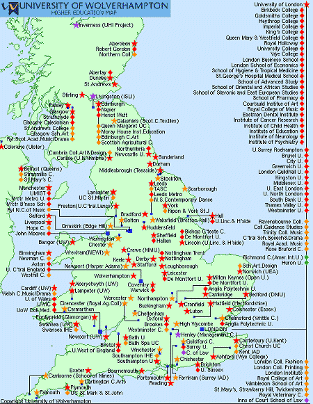
How do you organize a list of your favorite, useful websites? Organizing items of similar information so they can be easily searched or browsed to find one particular one requires an intuitive indexing system, and is a problem that has challenged archivists, librarians, and scholars for generations. Clearly there are many possible ways to index a list of websites–you might order them alphabetically based on title or domain name (from Amazon.com to ZDNet), or chronologically (based on when you last accessed the site). Alternatively, you might group them thematically based on the type of information or services they provide (with categories like sports, health, finance, games, etc), or order them by popularity, or even by the size of the site. The major Web portals do indeed apply many of these methods. Geography can also be used as an index. Location is a widely used as powerful means of organizing information. For example, it is used by governments to collect taxes, elect politicians and undertake censuses. Maps provide an intuitive visual tool to browse geographically indexed information. A whole industry has grown up around the power of location and mapping, known under the banner of Geographic Information Systems (GIS) [1]. Geography has also been used to index websites in form of so called sensitive maps. These maps are website directories, with individual sites indexed by their latitude and longitude (often just to the nearest city). Sites are shown on the maps as dots, which act as hotlinks to the homepage of the website. One of the best examples of a sensitive map is the UK Academic Map, maintained by the University of Wolverhampton, UK [2].
This map provides a visual directory to the websites of the universities and colleges in the United Kingdom based on their geographic location. You simply click on the dot or the university name and you are taken to the appropriate homepage. Map of the Month discussed the map with its creator Peter Burden in a recent email.
The UK Academic Map went online in July 1994 (ancient history for the Web!), having being created, according to Burden, for a seminar to local industry chiefs showing them “the wonders of the Internet.” Burden is a professor in the School of Computing and Information Technology at the University of Wolverhampton. He is interested in cartography, as he said: “I've always been fascinated by maps and possess a complete set of 1" to the mile OS maps, and that's a fairly small part of the collection.” In the early days of the Web, circa '94-95, sensitive maps like this one were a popular way of cataloguing websites, with many cities and countries having one. At that time the Web was orders of magnitude smaller than today and it was possible for people to maintain these maps manually. However, the sensitive map approach did not scale well to keep pace with the tremendous growth in both the number and type of websites and services available. And most sensitive maps have either been taken down or abandoned in a forgotten corner of the Web. The UK Academic Map is one of few examples that is still maintained and useful, largely because it specializes in indexing a limited segment of websites–those of UK universities–which is relatively static in size. The current map shows 204 different institutions. According to Burden, the main strength of the sensitive map is that “... a very large number of links are presented in a natural way in a small amount of screen real-estate” and that the mapping approach is most appropriate “... for resources that have a natural geographical association.” The maps are most useful showing a 'big-picture' overview of a lot of information.
Clearly there are limitations with sensitive maps, both in terms of cartographic design and at the conceptual level of information indexing. Burden wryly notes that these maps, “...for non-geographical resources can be rather confusing.” In the case of university websites it is appropriate because this type of organization is strongly associated with a location. (Indeed many are named after the city or town they are in.) But for many other websites, a geographic location is not an appropriate index. For example, where would you draw the dot on the map to represent Amazon.com or ZDNet? Locating the site at their headquarters would have little relevance to most people searching the Web. Another important issue with using geography as the index is that a lot of people have a bad sense of geography in terms of finding cities or countries on a map. Americans seem to be particularly notorious for their geographic illiteracy [3]. Burden reports for example, that he “...occasionally receives messages to the effect of 'where's Lampeter University?' ... it turn[s] out that the message was from somebody overseas whose knowledge of UK geography was rather rudimentary and certainly didn't extend to knowing the whereabouts of Lampeter.” [4] So, for some people, using geography as the indexing key may make information navigation harder compared to, say, browsing through an alphabetic list. In cartographic terms, producing sensitive maps for the Web has many of the same design challenges as conventional map-making [5]. Symbols can quickly become cluttered as many websites are obviously clustered in large cities that cover a relatively small geographic area in relation to the amount of information they contain. This is exacerbated in the UK Academic Map because all the symbols need to be labeled with long university names. Problems are most apparent with the high density of universities in cities like Manchester and London, for example, making the designer's job difficult in placing all the symbols, and particularly their labels, so that they do not overlap.
In the last year or so there seems to have been a resurgence in the use of geography to “geo-enable” the Web. This is partly in response to the rapid growth of the Web and the well known problems of “information-overload” [6], the hope being that providing geographic knowledge within the Web will help people to find more relevant sites and services. Another factor has been the tremendous growth in mobile devices like phones and PDAs, which, by enabling communications anywhere, seem–somewhat perversely–to enhance the importance of location [7]. A number of companies are developing geographic services for websites to determine, in real-time, the location of their visitors and thereby provide them with more relevant, tailored content. Some of the key players in this field are Digital Island with their TraceWare technology, Quova's GeoPoint service, and Digital Envoy's NetGeography [8]. They believe there is a market for technologies that can “localize” the Web by reliably determining people's physical location (which often really means at the level of territorial jurisdiction). The need for this localization has been shown in a number of recent cases, such as selling Viagra over the Web, re-distributing TV programs [9], online gambling, and even selling Nazi memorabilia [10]. There are also interesting developments in geographic-aware search engines (such as iAtlas or Somewherenear [11]), as well as a scheme called Geo Tags [12] to provide location metadata within individual Web pages. There is even a well developed proposal for a completely new top-level domain of .geo, which aims to “... provide an open and scalable infrastructure to index, discover, and serve any information on the web based upon the latitude-longitude location of the data being referred to.” [13] So it might soon be time to register your house location as a Web address to block a new generation of cyber-squatters! As for the UK Academic Map, Burden has no great plans for further expansion, although “... somebody said the other day that there ought to be a scale on the map, quite right too.” Map of the Month also asked him what his ultimate map of the Web would be, he replied, Something that allows automatic zooming with automatic name placement (rather like the impressive Encarta Atlas) only going down seamlessly to much finer detail, combined with a geographically aware search engine, so you could define an area on the map and then ask for all the bookshops (or whatever) in your selected area. Must write that up as a research proposal! [14] So the days of the geography-free Web may be numbered, as cyberspace is brought back down to Earth. Copyright © 1999, 2000 media.org. ISSN: 1530-3314 |
|||||||||||||||||||||||||||||||||||||||||


|