Pastures in the Sea
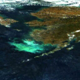
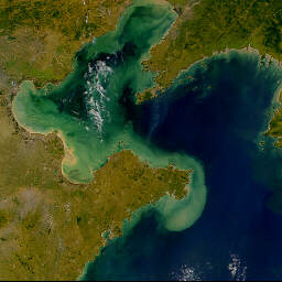
The oceans aren't just blue. In some
parts, cool waters rich in fertilizing nutrients spring up from the dark
abyss into the full glare of tropical sunlight. This convergence stimulates
phytoplankton blooms; lush pastures of microscopic plants that form the
foundation of marine ecosystems on much of our ocean planet. If the upward
flow of nutrients is interrupted, the same expanse will soon lose its
greenish hue as the warming, infertile waters become incapable of supporting
much life.
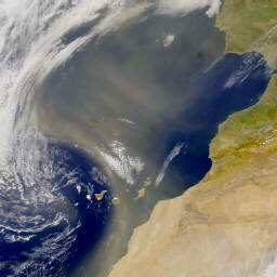
Near the poles oceans are often white
from a cover of ice and snow. Along coasts sediment from rivers and floods
can turn the water a muddy brown. Vast dust storms spin out over the
Atlantic from the Sahara and over the Pacific from central Asia. In bays,
the ominous spread of a red tide can be deadly for fish and harmful to
humans as well. Oil is spilled. The human hand leaves fingerprints of
pollution.
All of these variables are reflected
in ocean color. But often these variations occur at such a large scale it
is difficult to study them based on surface observations. To help
scientists achieve a better understanding of ocean dynamics through careful
observations of ocean color NASA launched the SeaStar satellite on August 1,
1997, as part of their "Mission to Planet Earth". The SeaStar carries the
"Sea-viewing Wide Field-of-view Sensor". Thankfully, it's usually simply
called "SeaWiFS".
Over the past two years, SeaWiFS has
been serving up a feast of spectacular images and data. As its capabilities
have become more widely recognized SeaWiFS' gaze is being turned toward the
earth's landmasses and atmosphere as well. Background information and many
interesting, newsworthy and spectacular images are available to the public
on the official SeaWiFS web site at seawifs.gsfc.nasa.gov.
In this edition of Trip-M, NASA
Oceanographer M. Grey
Valenti explains the SeaWiFS project in an interview with Marty Lucas
conducted May 14, 1999.
 |
"SeaWiFS looks at ocean color"
|
 |
|
|
|
 |
|
 |
|
MGV: SeaWiFS looks at ocean color to determine what's in the ocean whether it be phytoplankton concentrations or pollution.
ML: It's all about the color of the ocean isn't it?
MGV: It is, however, even though it was designed to look at the water, it's also good to look at the color of land and atmosphere, so it's also good for tracking land vegetation, and atmospheric phenomena such as hurricanes or smoke, like last year during the El Niño there were a lot of forest fires, in Mexico and Florida and firefighters were using SeaWiFS because they could see the smoke plumes. Also things like dust, Sahara dust comes out over the oceans. In Asia there was a dust storm that killed a bunch of people and that dust storm they could track it in all the way across the Pacific Ocean and see it arrive in Seattle.
ML: Have you run across any phenomena using SeaWiFS that hadn't previously been observed?
|
"what the temperature is affecting is life"
|
|
|
|
|
|
|
|
|
|
|
|
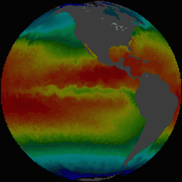
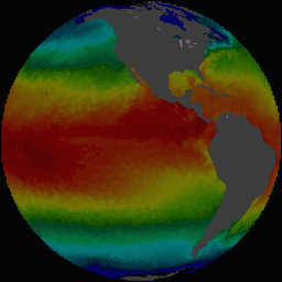
MGV: Well the El Niño was not previously observed from a life point of view. People were observing El Niño with temperature, and of course it was observed on the ground. You were able to observe the fish kills. And in a place like Galapagos, when the fish died, the sea lions that eat the fish also died. So there was lots of data from people that were local, but nobody was able to observe the disappearance of phytoplankton in the Pacific Ocean on the scale that you could before SeaWiFS. Before we were tracking things like El Niño with temperature, but what the temperature is affecting is life, and so this is the first El Niño, this El Niño that just past, that we've actually been able to monitor how the life was changed by the El Niño cycle.
ML: So when you see the El Niño cycle on the ocean, where is that happening? Is that really broadly over the oceans, or is it centered in certain areas?
MGV: Well, oceanically it's mainly a Pacific Ocean phenomenon. But when you move that much warm water, that far across the globe, it changes weather everywhere.
ML: Well the thing I often hear about when I hear about El Niño at least on the west coast or South America is that typically there's an upwelling of cold water there that's nutrient rich that results in biologically rich area and then when El Niño shifts, warm water accumulates there and somehow it's funny, we think warm would be good, but somehow warm isn't so good in this context.
MGV: To grow plants you need water, you need sunlight and you need nutrients, like fertilizer. In the ocean of course water is not a problem. Light only penetrates the upper hundred, sometimes even only the upper ten meters of the water. And nutrients are in the cold rich deep water. So to grow phytoplankton you need the rich cold water to meet with the light zone, which is on top. This usually happens in coastal zones and around the equator. You know from when you're swimming, there'll be a layer of hot water on top and then there's a very sharp line between where the hot water stops and where the underneath water is cold? Well, when El Niño happens, the hot water from the coast of Asia moves across the whole Pacific Ocean and it caps the upwelling cold water and then the nutrient rich water cannot make it up into the light zone.
ML: And how does this then appear in SeaWiFS data?
MGV: On SeaWiFS data you can see when the nutrients are shut off, there's no life. And then when the warm water recedes and the nutrient rich water is able to get back into the light zone, there's a giant, giant bloom. And it happens fast, like a matter of days.
ML: So these organisms must be present there ready to take advantage of this nutrient just like plants in the desert can appear very rapidly after a rain fall?
MGV: Right.
ML: And what do we see when we look at the North Atlantic?
MGV: Well in addition to seeing the phytoplankton you can see things like oil spills, pollution, red tides and certainly the Florida guys are looking at red tides with SeaWiFS.
ML: What is a red tide exactly?
MGV: It's red brown algae that gives off fumes that are toxic. Like if we were to go to the beach and there was a red tide, the fumes coming off the water would be toxic and it would be very difficult to breath and it would be hard on our eyes, but it also causes fish kills, so there'll be tons and tons of fish washed up dead on the beach when there's a red tide.
|
"oil spills, pollution, red tides"
|
|
|
|
|
|
|
|
|
ML: What would you tell to people who are interested, interested non-professionals in particular about how they can take advantage of the SeaWiFS program to understand the oceans better and their world in general including terrestrial ecosystems?
MGV: Well the SeaWiFS has a very extensive web page, almost everything that you'd want to know about SeaWiFS is on the web. And we have an extensive image gallery, so that even if your not a scientist and you're not going to be able to order the data from us, you can still see a lot of great images, so you can look at the El Nino data and you can look at hurricane Bonnie, you can look at the Asian dust storm, all on the web. And that's something that a non-scientist can grasp just with a picture. A picture paints a thousand words.
ML: What is the decision process that goes behind what SeaWiFS decides to publish publicly and what doesn't get published.
MGV: Well, we cover the globe every two days. So we have a lot of data, and obviously it can't all go up on the web. So part of it is; Did it make news? Was it interesting from a news point of view? Part of it is; Is it a stunning image?
ML: How does it take into account all the other variables, like atmospheric conditions, and maybe how much turbulence or wave forms there might be on the sea surface. Or even maybe the seasons may have light at different angles. What kind of things like that are factors that you have to consider?
MGV: There's a lot of them. Atmospheric correction is a big one, zenith, nadir, angle all that kind of stuff the optics of how the satellites seeing is important. But also things like, people will, there's all kinds of special science sessions where people get together and bicker for weeks about how to tell the difference between phytoplankton versus sediment runoff in the water. It's sort of how to determine what we're seeing, and because this was designed for oceans and not for land, the land guys are sort of beginning to get on line with SeaWiFS and equations to figure out exactly what they're seeing with land, and the atmospheric guys are beginning to come on line too.
Copyright © 1999, 2000 media.org.
|