 |
 |
Stephanie Faul is director of public relations for the
AAA Foundation for Traffic Safety. A long-time writer and
editor, she has been a frequent contributor to on-line
and old-line media.
Locus is a series about words about places and how language, culture and society have created and used these
words down through the ages.
» Previous Issues
|
 |
 |
 |
 |
» In 1570, Gerardus Mercator assembled his Atlas of Europe in preparation for a grand tour by the Crown Prince of Cleves. The book disappeared until 1967, when it was purchased unrecognized by a Dutch collector from an antiquarian bookstore in Brussels. The original was acquired by the British Museum for 1.2 million dollars and is available for viewing by special appointment only. In 1998 Walking Tree Press published a restored replica, allowing the public to see the first detailed maps of early modern Europe. Though pricey, the sumptuous volume has received universally glowing reviews.
A review of The Mercator Atlas of Europe in January Magazine
|
 |

Buy the Book Today! |
 |
 |
|
More about
Projection Maps

» Map Projection Basics from the Department of Geography Hunter College of the City University of New York.
» Nova Et Aucta Orbis Terrae Descriptio Ad Usum Navigantium emendate . . ., Gerard Mercator's famous world map, 1569 Jim Siebold and (Henry-Davis Consulting)
» Mercator projections and navigation.
» Mercator maps of Finland
» mathematics of the Mercator projection
» According to land surveyor Fred Roeder, Mercator
worked by mathematical analysis and his map is therefore not a
projection. Read Antepasados: Mercator, Surveyor and Mapper.
» T. S. Eliot: "The Hollow Men"
|
|
 |
 |
|
|
 |
 |

Projection
A map projection attempts to represent one reality in the context of another. In cartography, this means representing a round object, the earth, on a flat surface, paper. The word derives from the Latin “pro,” meaning “forward,” and “iacere,” “to throw.” (Thus, a movie is “thrown forward” onto a screen.)
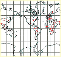
The most familiar projection is that of Gerardus Mercator (1512-1594), a Flemish geographer. Mercator envisioned the spherical earth contained in a cylinder. He produced a map with a symmetrical grid in which the meridians are shown as parallel lines. Though it revolutionized cartography, Mercator’s projection seriously distorts extreme latitudes; Greenland appears huge and Antarctica looks like a white elephant lying along the South Pole, which takes up the entire bottom edge of the map. In addition, on a Mercator map a straight line drawn between two points is often not the most direct route.
Other projections avoid the errors of Mercator but insert distortions of their own. Some represent shape accurately, but not distance; others the reverse. A conic projection envisions the earth in a cone (imagine a Sno-Cone) and then flattens out the result. Shapes of the target area are preserved, but not distances. An azimuthal projection takes a specific point and flattens out the surface around it (imagine smashing an orange onto a plate). While it shows accurate distances from the target area, it
distorts the peripheral shapes.
Like a still photograph, a map projection freezes a mutable three-dimensional object into a static two-dimensional image. Since the earth is three-dimensional and constantly changing (albeit slowly), no two-dimensional map can show its surface with complete accuracy. As T.S. Eliot says in “The Hollow Men” (1925):
“Between the idea
And the reality
Between the motion
And the act
Falls the Shadow”
Copyright © 1999, 2000 media.org.
|
 |


