 |
|
|
|||||||||||||||||||||||
|
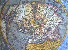
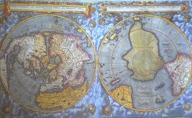
Finding the Poles
Don't look now, but you're moving. So is everything around you. The earth turns on its axis, which not only brings day followed by night but which also means its surface and everything on it is constantly rushing around. Only the north and south poles remain still: Should you stand at either one, you would merely turn in place. Think of a basketball being twirled by Meadowlark Lemon of the Harlem Globetrotters-it's twirling madly, except for that one spot where he puts his finger. The word "pole" comes from the Greek "polos," or "hub"; the part of a wheel around which all else revolves. A pole-centered map projection does indeed look like a wheel, with all the meridians converging at the center and parallels spreading outward in circles; north is in, south is out, east is counter-clockwise. In truth earth has several poles; not only the geographic poles, but magnetic poles and geomagnetic poles. Before the discovery of the magnetic compass, mariners used stars to find directions, since they appear fixed in space. Most important was the star over the North Pole. But the earth wobbles on its axis every 26,000 years, which means that over the millennia the pole star has changed. For the Greeks the star was located in the constellation of the Big Dipper, which they called "The Great Bear," and is the root of the word "arctic"-the Greek word "arktos" means "bear." ("Antarctic" simply means "opposite the arctic.")In 2,000 BC the pole star was in the constellation Draco; 10,000 years from now Vega will become the pole star. At this time Polaris in the Little Dipper marks the pole very accurately, since the earth's wobble has moved the north pole to within less than one degree of the star. Early mapmakers assumed that since compass needles point to it, the North Pole must contain an enormous iron mountain. They also assumed the South Pole was located in "Terra Australis," an enormous but imaginary continent that balanced the large land masses in the northern hemisphere and was named for Auster, the wind that blew from the south. Sir William Gilbert, a doctor in the court of Queen Elizabeth I, was the first to discredit the iron mountain theory by postulating that the earth itself is a giant magnet. He also assumed that the celestial pole and the magnetic pole were the same. They're not. The earth's core contains molten iron, which flows constantly and creates a magnetic field. Because the core is always in flux and because the solar wind affects magnetic forces, earth's magnetic poles shift constantly, even from day to day. In 1994 the magnetic north pole was located near Ellef Ringnes Island in the Canadian Arctic, around 1,400 km from the geographic pole; it moves toward the northwest by approximately 15 km per year. Similarly, over the past century the southern magnetic pole has moved from the Antarctic continent out to sea. At the magnetic poles a compass needle will point straight down, since the lines of force at that point are perpendicular to the surface.
In addition to the magnetic poles, earth has two "geomagnetic poles." These are calculated rather than observed, by treating the earth as a giant dipole magnet and figuring out where its poles would be; the north geomagnetic pole is located in Greenland. As the least accessible regions on earth, the poles have attracted their share of romantic fantasies. Some people thought that the polar seas would actually be warm, since in theory they remain still. Others postulated great openings at the poles that would allow entrance to the earth's interior. Polar areas remained largely unvisited and unmapped until the 20th century, when technology helped explorers overcome the barriers of nature. Antarctica, for example, lies under a thick sheet of ice, and only recently has sonography produced an accurate representation of the land under the glaciers. Plug "north pole" into any search engine, however, and the top hits will involve Santa Claus, who lives there. This bit of "folklore" sprang from the pen of cartoonist Thomas Nast in the 1870s; presumably he chose the North Pole because it was so inaccessible. But there are other advantages to a North Pole toy factory. Santa can not only avoid nosy visitors, he and his elves can put in the the world's longest workday-between March and September, the North Pole gets six straight months of sunlight. Copyright © 1999, 2000 media.org. |
||||||||||||||||||||||||
|