|
|
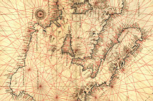
Portolan
In the 13th and 14th century, Italian navigators developed the
"portolano," a book that listed seaways, ports, and anchorages, as well as containing accurate and useful nautical maps. The English "portolan" is a shortened version of the word, which means "little port." Such charts were also called "rutters," from the French "routier," meaning "something that finds a way."
Since the sea itself is featureless and sailors have no need of knowledge
beyond the shore, portolan charts traditionally show only the blank ocean
and its edge. Lines connected important destinations across the sea,
while the land areas were left blank. Thus, on a portolan chart seaside
cities look like stars, with lines radiating from them to show the compass
headings for various destinations.
The discovery of the magnetic compass in the 12th or 13th century
revolutionized navigation. Mariners could confirm their course without
relying on the sun or stars, since the needle always pointed in the same
direction. (European compasses pointed north. Chinese compasses,
developed around the same time, pointed south. It is not clear who came
up with the idea first.)
With a compass and a portolan chart, a navigator could leave port going in
a specific direction, stay on that course, and arrive at land reasonably
near his intended destination. Sailors could move out into the open ocean
without having to follow along the shore or navigate from landmark to
landmark, and could continue confidently on course even in cloudy weather.
Thus, compass-and-chart navigation made it possible to "jump" from one city to another across the featureless sea.
Copyright © 1999, 2000 media.org.
|
|